
-
By

- February 12, 2025
- Urban Survival Essentials
Urban Navigation Without a Phone: Methods for City Survival
Lost in the City? Here’s How to Find Your Way Without a Phone
Ever been stranded in a city with a dead phone and no idea which way to go? It’s easy to rely on GPS, but real urban navigation skills can help you get around without staring at a screen. Whether you’re in a blackout, out of battery, or just want to sharpen your sense of direction, knowing how to read the city the old-school way is a game changer.
Let’s discuss some tried-and-true methods for navigating urban environments without modern tech.
The Power of Observation: Using Landmarks and the Sun
Phones die, but landmarks don’t. Every city has unique markers that can help you figure out where you are and where you need to go.
1. Spot the Landmarks
- Tall buildings and towers – Most cities have a few skyscrapers or towers that stand out. Use them to get your bearings.
- Bridges and rivers – If a city has a major river running through it, knowing which side you’re on helps with orientation.
- Parks and plazas – Large open spaces like central parks, town squares, or markets are easy reference points.
2. Use the Sun as a Guide
Even in a city, the sun is your best directional tool:
- Morning: The sun rises in the east. If you see the sun rising over a landmark, you know that direction is east.
- Afternoon: The sun moves west, so shadows point east.
- Evening: Sunset means west. If you face the setting sun, north is to your right, south to your left.
Using these cues, you can build a mental map of the city—even if you’ve never been there before.
Mastering the Art of Map Reading
Carrying a physical map might sound outdated, but if your phone dies, it’s the smartest backup.
1. Why You Need a Paper Map
- Doesn’t require a battery or signal.
- Gives you a full view of the city’s layout.
- Helps you understand street patterns and distances.
2. How to Read It Like a Pro
- Check the legend. Learn what symbols mean (bus stations, parks, one-way streets).
- Understand the scale. A half-inch on the map could mean a five-minute walk—or a twenty-minute one.
- Look for major roads. These are usually bolded, making them easier to follow.
3. Read Street Signs for Extra Help
Most cities have:
- Directional signs showing north, south, east, and west.
- Numbered streets that increase or decrease in a pattern.
- Neighborhood markers that tell you what district you’re in.
Even without a map, reading the street signs can help you piece together where you are.
Using Public Transportation Maps to Your Advantage
Even if you’re not taking the subway or bus, transit maps can give you a clear sense of the city’s layout.
1. Find a Station or Bus Stop
Most transit hubs have large maps posted near ticket machines or entrances. Take a minute to study them.
2. Use Transit Maps as City Guides
- Metro maps show major neighborhoods. Even if you’re walking, knowing which station is closest to your destination helps.
- Bus routes follow key roads. If you see multiple bus stops along a street, it’s probably a main road that leads to important places.
- Train lines often run in predictable directions. For example, in many cities, the red line might go east-west, and the blue line might go north-south.
This trick works even if you don’t plan to use public transport—just knowing how the system is laid out can give you a better sense of direction.
Navigating Through Human Interaction: Asking for Directions
When all else fails, just ask. Locals are one of the best resources for urban navigation, but there’s a right way to go about it.
1. Who to Ask for Directions
Not everyone knows their city well, and not everyone gives good directions. Stick to people who are more likely to be familiar with the area:
- Street vendors – They stay in one spot and interact with a lot of people, so they usually know the area well.
- Security guards – Often stationed at buildings, they can give directions to major streets or landmarks.
- Store employees – If you’re near a business, stop in and ask someone behind the counter.
- Transit workers – If you’re near a bus stop or train station, drivers and station attendants can point you in the right direction.
2. How to Ask for Directions the Right Way
People are more likely to help if you make it easy for them. Here’s how to get clear answers:
- Be specific. Instead of asking, “Where’s downtown?” say, “How do I get to [specific street or landmark]?”
- Use landmarks. If you have no idea what street you need, ask about well-known places: “Which way is the main square?”
- Confirm details. Repeat back what they said: “So, I walk three blocks, take a left at the church, and it’s straight ahead?”
Being direct saves time and makes it more likely you’ll get accurate directions.
Cracking the Code: Understanding City Grid Systems
Some cities are easy to navigate because they follow a grid pattern, while others are more of a maze. If you know how the layout works, you can get around a lot faster.
1. How Grid Systems Work
- Numbered streets – Many cities use a numerical system where streets run in order (1st Street, 2nd Street, etc.), making it easy to figure out if you’re moving in the right direction.
- Lettered avenues – Some cities use letters instead of numbers (A Street, B Street, etc.).
- Cardinal direction labels – Some cities split into quadrants (NE, NW, SE, SW). A street name with “NW” tells you it’s in the northwest section of the city.
2. What If the City Doesn’t Have a Grid?
- Follow major roads. Most cities have key streets that lead to important areas—if you find one, stick with it.
- Use landmarks. If the streets don’t make sense, rely on major buildings, rivers, or parks to guide you.
- Pay attention to traffic flow. If the streets seem chaotic, look for where the most foot traffic is going—it’s probably leading to a central hub.
Understanding the city’s layout makes a huge difference in how quickly you can get where you need to go.
The Role of Traditional Navigation Tools
While most people don’t carry a compass in the city, a few old-school techniques can keep you from getting lost.
1. Carry a Small Compass
It’s lightweight and doesn’t need a signal. Even in an urban setting, a compass helps when landmarks aren’t visible.
- If you know your destination is north, keep the needle pointing that way.
- Use street angles to estimate direction. If the city is on a grid, most streets run either north-south or east-west.
2. Dead Reckoning: Tracking Where You’ve Been
This method involves keeping track of:
- Where you started – Mentally mark your starting point so you can retrace your steps if needed.
- Direction of movement – Note if you’ve been walking mostly north, south, east, or west.
- Landmarks passed – If you walk past a church, a big intersection, or a statue, remember it—it’ll help you backtrack if necessary.
This is how people navigated before maps and phones. It takes practice, but it’s a great backup if you ever find yourself in an unfamiliar place.
Observing Environmental Cues for Navigation
Cities leave clues everywhere—you just need to know where to look.
1. Follow Traffic Flow
- In the morning, most foot traffic moves toward business districts.
- At the end of the workday, people move toward transit stations and residential areas.
- Weekend traffic is different—watch where tourists gather, as they often stick to well-known areas.
2. Look for Clusters of Businesses
Certain businesses tend to be grouped together in specific parts of a city:
- Financial districts have banks, corporate offices, and high-end coffee shops.
- Shopping areas have major department stores, malls, and lots of foot traffic.
- Industrial zones have warehouses, factories, and fewer pedestrians.
Recognizing these zones helps you understand what part of the city you’re in, even if you’re lost.
Preparing for Urban Navigation Without a Phone
If you want to get better at urban navigation, the best thing you can do is practice.
1. Try Navigating Without Your Phone on Purpose
- Pick a destination and try to get there without GPS.
- Use only street signs, landmarks, and a map if needed.
- Test yourself by choosing different routes each time.
2. Carry a Basic Navigation Kit
You don’t need much, but having these in your pocket can help:
- A small map – Foldable and easy to stash.
- A compass – Takes up no space but can keep you from getting turned around.
- A watch – Helps you estimate walking time and distance.
Building these skills now means you won’t panic if your phone ever dies when you really need to get somewhere.
Becoming an Urban Pathfinder
Once you ditch the GPS and start paying attention to your surroundings, you’ll see the city in a whole new way. Instead of blindly following directions, you’ll know how to get around just by reading the streets, understanding patterns, and using old-school navigation tricks.
Recap of Key Navigation Skills
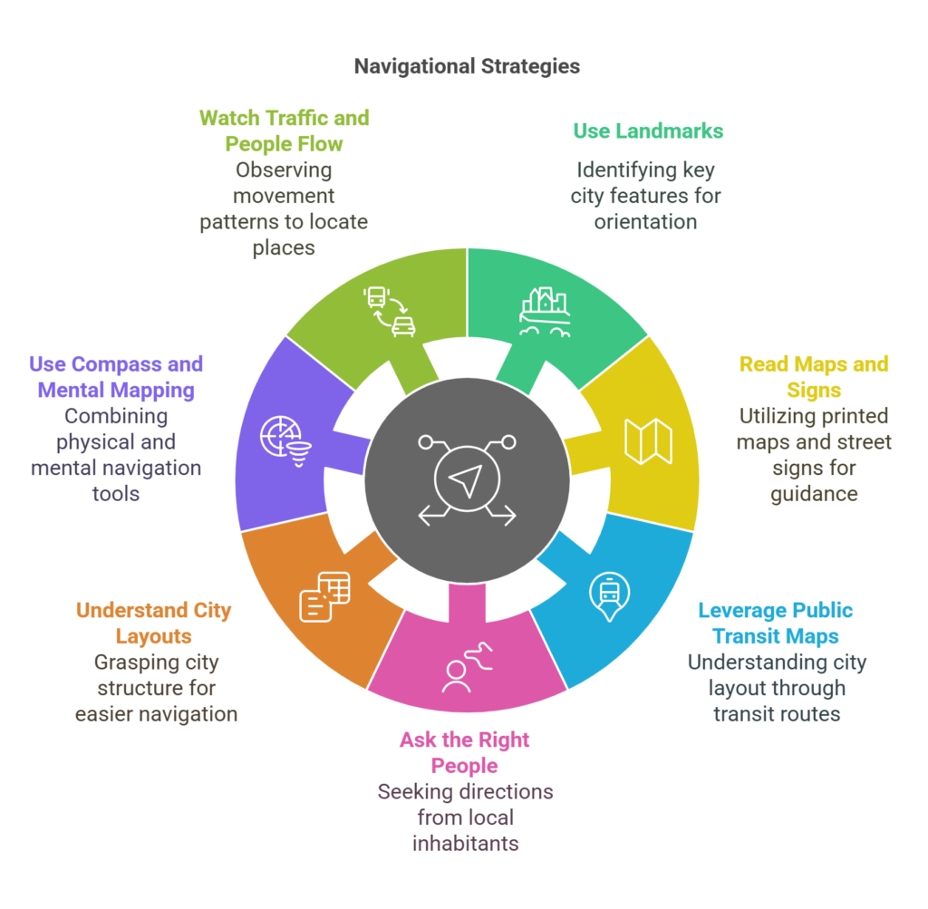
If you only remember a few things, make it these:
- Use landmarks – Skyscrapers, rivers, bridges, and parks are your best reference points.
- Read maps and street signs – A paper map still beats a dead phone, and street names can tell you a lot.
- Leverage public transit maps – Even if you’re walking, subway stations and bus routes reveal how the city is laid out.
- Ask the right people – Vendors, security guards, and store employees usually give the best directions.
- Understand city layouts – Grids are easy, but even non-grid cities have major roads that can guide you.
- Use a compass and mental mapping – Old-school tricks like dead reckoning help when everything looks the same.
- Watch traffic and people flow – Where the crowd goes, important locations follow.
Test Yourself: A Simple Urban Navigation Challenge
Next time you go somewhere new, try this:
- Step 1: Leave your phone in your pocket and navigate using only street signs and landmarks.
- Step 2: If you get lost, stop and figure out your location before pulling out a map.
- Step 3: If you have to ask for directions, ask a local and repeat their answer to confirm it.
- Step 4: Challenge yourself to navigate a few blocks without checking anything at all.
The more you practice, the better you’ll get at navigating without a phone. It’s a skill that can come in handy whether you’re traveling, dealing with an emergency, or just exploring your own city with fresh eyes.If you’re up for it, spend a day navigating like it’s the 90s—no apps, no digital maps, just you, your instincts, and the streets around you. You might be surprised how much you actually see when you’re not relying on tech. Something we’ve all become accustomed to.


